http://www.colorado.edu/geography/extra/geogweb/bouldercreek-2/preview/page2.html
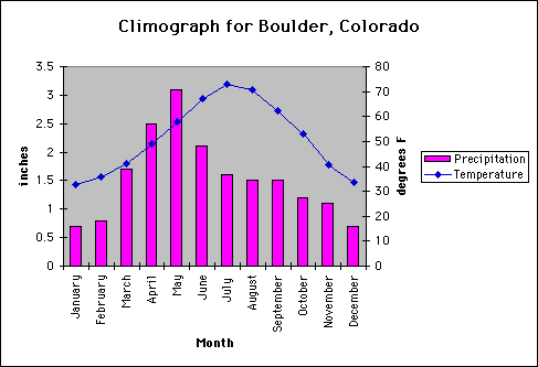
A climograph is a graphical representation of the amount of precipitation and temperature felt at a particular loaction. It is a very convenient and quick way to view the climate of any area. The way you read a climograph is very simple. All you have to do is find the particular month that you want to see the climate for and the bar graph portion represents the amount of precipitation and the curve is the temperature. There are values on both sides of the climograph to show units for both variables. In this climograph, Boulder, Colorado is the city being measured. As you can see, May had the most precipitation and July was the hottest month of the year.
No comments:
Post a Comment